
Understanding DEM, DTM, and DSM
- Rojan
- Aug 5
- 3 min read

Digital Elevation Models (DEMs) are at the heart of geospatial analysis, providing a three-dimensional view of the Earth’s surface. They are indispensable in fields like flood modeling, urban planning, infrastructure development, and environmental management.
However, not all elevation data is the same. Within the broad category of DEMs, three terms often come up, DEM, DTM, and DSM. While frequently used interchangeably, they each represent a different way of modeling the Earth’s surface. Understanding the differences is critical for choosing the right data for your project.
In this post, we’ll break down the distinctions, features, and applications of DEMs, DTMs, and DSMs.
What is a DEM?
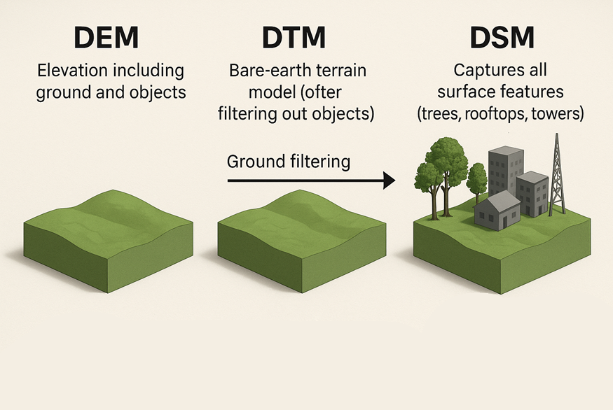
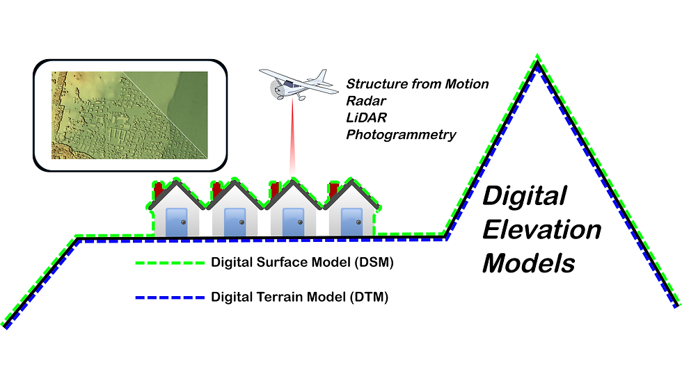
A Digital Elevation Model (DEM) is a general term for a digital representation of the Earth’s surface that captures elevation values across a grid. It reflects the height of the terrain above a reference point, usually sea level.
DEMs can be generated using various technologies such as:
LiDAR (Light Detection and Ranging)
Photogrammetry
Satellite remote sensing
Applications of DEMs
Flood Modeling: Simulate water flow and predict flood extents in vulnerable regions.
Watershed & Hydrology: Delineate watersheds and model how water moves across a landscape.
Infrastructure Planning: Evaluate terrain conditions before constructing roads, bridges, and other projects.
What is a DTM?
A Digital Terrain Model (DTM) is a more specific type of DEM that represents the bare Earth. In other words, it removes buildings, vegetation, and other surface objects, providing a clear view of the natural ground surface.
DTMs are typically created by filtering out non-ground points from LiDAR data or other elevation sources.
Key Features of DTMs
Focus solely on natural terrain features, hills, valleys, slopes.
Ideal for applications where ground accuracy is crucial.
Applications of DTMs
Engineering & Construction: Support road, bridge, and tunnel design with precise terrain data.
Environmental Analysis: Assess erosion patterns, slope stability, and land-use planning.
Hydrological Modeling: Provide an accurate foundation for simulating water flow and drainage.
What is a DSM?
A Digital Surface Model (DSM) captures everything on the Earth’s surface, including trees, buildings, and other structures. Unlike a DTM, it represents the first reflective surface, making it perfect for understanding the built environment or canopy coverage.
Key Features of DSMs
Include both natural and man-made features.
Derived from first returns in LiDAR or photogrammetry, reflecting the highest point of objects.
Applications of DSMs
Urban Planning: Analyze building heights, shadows, and line-of-sight studies.
Telecommunications: Optimize placement of communication towers and study signal propagation.
Forestry & Ecology: Estimate forest canopy height, biomass, and wildlife habitat.
Comparing DEM, DTM, and DSM
Feature | DEM | DTM | DSM |
Representation | General elevation data of the Earth's surface | Bare-Earth ground surface | Surface including buildings, vegetation, etc. |
Data Type | Broad term covering various types | Ground-only model | Surface model including all features |
Applications | Flood modeling, general terrain analysis | Engineering, hydrological modeling | Urban planning, telecommunications |
Choosing the Right Model for Your Project
Use a DEM for general elevation analysis and hydrological studies.
Use a DTM when you need accurate bare-earth terrain for engineering, construction, or water flow modeling.
Use a DSM for urban studies, forestry, or any application involving the surface and its features.
Understanding the distinction between these models ensures your analysis is accurate and fit for purpose. Whether you are mapping flood risks, planning urban infrastructure, or studying forest canopies, choosing the right elevation model is a foundational step toward actionable geospatial insights.


Comments